


How can historical weather data help verify insurance claims?
Weather Data for Insurance and Risk Management
Weather is essential intelligence for the insurance sector because of the massive losses that can occur with extreme weather events. However, general weather data often doesn't provide the tools needed to evaluate events at the local level.
With weather data for insurance and risk management, you can more precisely assess losses from extreme weather events, reducing financial burdens and enabling better underwriting procedures. This also helps you service policyholders more effectively by quickly verifying claims and evaluating total storm impact.
With weather data for insurance and risk management, you can more precisely assess losses from extreme weather events, reducing financial burdens and enabling better underwriting procedures. This also helps you service policyholders more effectively by quickly verifying claims and evaluating total storm impact.

Turn weather records into faster claims and risk decisions
While the everyday person may rely on a general forecast, insurance companies need to analyze both long-term weather patterns and real-time storm data.
Long-term weather patterns are crucial for assessing risk and adjusting insurance policies to account for shifting weather patterns, such as stronger tropical cyclones driven by climate change. Even smaller, local patterns, such as whether a given creek bed floods every year, and help companies decide whether to insure a given restaurant or raise premiums in a neighborhood.
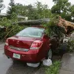
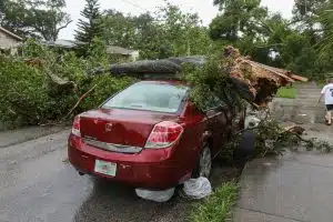
Once extreme weather strikes, insurance companies need a robust disaster response that verifies the timing, severity, and geographic impact of a storm. This can identify fraudulent claims and ensure smooth operations while teams process claims.
Available insurance & risk management for weather elements

Historical Weather Records
Gain a deeper understanding of when, where, and how often certain conditions occur, which is crucial for mitigating risk when underwriting.

Storm Event History
Confirm the timing and impact of severe weather events, like tornadoes or named hurricanes, to reduce claims fraud and speed up processing.

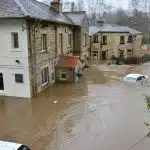
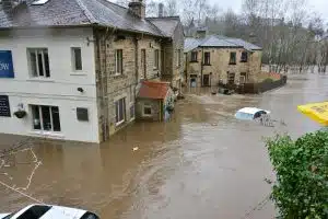
Precipitation and Flood Conditions
Use rainfall and flooding records to estimate losses and determine storm-related damages for both residential and business property claims.

Wind, Hail, and Severe Weather
Improve post-event investigation for windstorms, hail, and lightning strikes. Analyze potential exposure patterns and verify damage based on hyper-local wind, hail, or lightning data.

Location and Time-Stamped Verification
Manage claims more effectively, identify insurance fraud, and improve risk workflows with exact location matching and time-specific records.

Forecast Risk Signals
Prepare for extreme weather events with highly accurate, hyper-local storm coverage that can improve customer satisfaction while streamlining post-event workflows. Monitor your exposure to certain high-loss events with risk signals.
Key weather API features for insurance & risk management
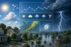
Historical and forecast data
Reports from ground-base stations & satellites and forecasts from global & local computer models for comprehensive risk analysis.

CSV and JSON Results
Obtain rich JSON structures or easy-to-use CSV from any API call, user-friendly for your entire underwriting team.
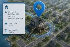
Location address geocoding
Precisely verify claim details for any location using an address, ZIP Code, latitude/longitude & more

Weather API or direct download
Query data using our RESTful API or download data via our web-based Query Builder for strategy meetings or cost analysis in service apps
How insurance and risk teams use weather data
Claim Verification
Weather data can help determine whether a reported event matches the severe weather alerts or the reported conditions at the time of the incident. Without clear weather information, it’s not always obvious if a claim is legitimate. Regional weather reports may show that there was widespread damage from a hailstorm, but a more granular dataset proves that only certain ZIP codes were impacted.
This improves decision-making, speeds up claims reviews, and provides stronger evidence for denials.
Risk Assessment
Exposure analysis and risk evaluation are key aspects of underwriting decisions and policy pricing. With accurate weather data, you can predict the expected conditions in that specific region and balance portfolios.
Risk is not evenly distributed across an entire region, which is why hyper-local records are key. Small geographic variations, such as being near a lake or in a valley, can completely change the risk levels for events like flooding, fires, or high winds.
Knowing the given exposure at one address versus one two streets over can prevent portfolio losses by accurately pricing premiums. This streamlines decision-making while providing clear explanations for pricing adjustments.


Catastrophe Modeling
Large-scale weather events like hurricanes can cause millions of dollars in damage, which is why insurers run models; these help them assess expected losses and identify warning signs of a major disaster.
Catastrophe analysis requires clear information on expected event severity, geographic exposure, and long-term precedents. With hyper-local weather data, you can precisely model risk and develop a disaster response plan that addresses all potential variables.
For commercial customers, catastrophe modeling can help you negotiate premiums or explain what the risks are of a proposed business location. By working together with clients, you can find satisfying underwriting solutions that will also protect their assets.
Fraud Detection
Insurance fraud often occurs when clients hear of disasters in other areas and assume insurers won’t scrutinize event maps. For example, they may learn that there was hail damage in the next town over and decide to pass off their dented car hood as hail damage.
With verified records from local weather stations, you can prove that certain service areas were not affected. This improves investigation workflows while also ensuring that verified claims are processed quickly. Having verifiable information helps you avoid costly disputes over denied claims. Customers will also recognize that they cannot provide false information, which reduces fraud over time.

Storm Impact Analysis
After severe weather strikes, insurance companies must analyze the scale, timing, and likely effects to estimate costs. This can become a time-consuming and labor-intensive process if you do not have access to high-quality reports. Customers will expect prompt responses to their claims and may become frustrated if they have to repeatedly provide information.
With clear and local weather data, operational response and damage review will be faster and more effective.
Start today for free
Sign up for a free account now and immediately begin using our weather API to query accurate forecast & historical data for any global location.
Our forecasts improve underwriting, policy planning, and operational response. Protect people and your bottom line through accurate weather data available with a single API call.
FAQs about Weather Data for Insurance & Risk Management
Confirming the weather conditions on a given date, location, and time makes it easier to determine whether specific damage was caused by a storm.
The most valuable records include precipitation, wind speed, severe weather mapping, lightning or hail data, and snow accumulation records.
Weather data can provide advanced warning of the types of weather common in a given area, enabling a tailored response. With storm data, insurers can assess the type, scale, and severity of impacts such as damaged roofs or water intrusion.
Weather data shows that the severe weather did not affect a specific area. For example, a customer may claim that their car was hit by hail, but weather maps show that the hail was actually concentrated two towns over. With this proof, claim disputes are easier to resolve.
Certain weather events move quickly and unpredictably; they may evolve over minutes rather than hours. Time-stamped weather records document the path of impact and can verify claims, while, for underwriting, knowing when certain weather events are likely to occur can improve risk assessments.