


How can weather data help reduce construction project delays?
Weather Data for Construction & Real Estate
he construction industry is highly weather-dependent; severe weather events can significantly alter timelines or pose serious risks to workers. Weather data for construction and real estate companies helps stakeholders at all levels of the organization better mitigate risk and protect assets.
Weather intelligence helps construction companies and developers pick the safest and most profitable project sites, which reduces the potential for costly losses from weather risk later in the project lifecycle.
Hyper-local weather data enables minute-by-minute scheduling and precise delay timing, which naturally flows into better project management. For risk management, construction companies can use real-time weather data to call work stoppages right before severe weather hits.
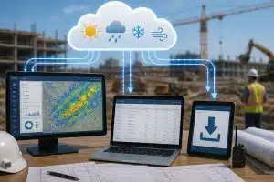
The Visual Crossing API is easily integrated into any project management or scheduling tool, allowing construction managers and developers to access global weather data with a tap. With our easy API calls, you can enjoy smarter decision-making and better resource allocation.
Plan around weather delays before they impact the project
General forecasts from places like the National Weather Service provide regional outlooks, but they don’t explain what’s happening at a specific site. Current conditions may differ significantly between two sites in the same city, leading to unnecessary disruptions when using a more generalized application.
With specialized data, construction and real estate teams can make more informed business decisions about schedules, project timelines, and site safety. This can reduce downtime and delays, ensuring that a project finishes on time and within the expected budget.
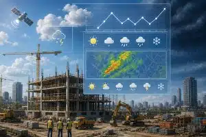
Available construction & real estate weather elements

Temperature
Temperature plays a significant role in the performance of construction materials, especially those that need to cure within a specific temperature range. Knowing when extreme temperatures are on the way can protect workers and help construction managers make more precise schedule adjustments.

Precipitation
Heavy rain or snow can make remote sites inaccessible, leading to significant weather-related delays. Precipitation may also alter soil conditions, making it hard to perform site inspections. By knowing the actual conditions on the ground, project managers can quickly adjust schedules and reduce the impact of the weather.

Wind
Wind speed is essential data for any work done at height, especially roofing and crane operations. Real-time weather information can help protect workers from dangerous wind gusts while keeping the site OSHA-compliant.

Severe Weather
Storms, lightning, hail, and other conditions often lead to complete site shutdowns and schedule changes. With severe weather alerts, managers can get workers to safety, protect the site, and prevent costly losses from material damage.

Hyperlocal Forecasts
General weather forecasts do not have the specificity needed to determine real-world conditions at a specific construction site. With hyperlocal forecasting, managers and developers can make more informed decisions about scheduling and worker safety.

Historical Weather Patterns
Historical weather data plays a pivotal role in determining what sites should be developed and how. With over 50 years of historical records, the Visual Crossing API makes climate profiling and project planning simple.
Key weather API features for construction & real estate
Historical and forecast data
Identify specific climate risks using decades of historical reports from ground-base stations & satellites, and leverage forecasts from global & local computer models for daily project planning

CSV and JSON Results
Obtain rich JSON structures or easy-to-use CSV from any API call, helping your team perform construction-specific statistical analysis in any programming language.
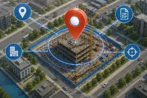
Location address geocoding
Drill down into site-specific data using an address, ZIP Code, latitude/longitude & more.
Weather API or direct download
Incorporate data into planning applications by using our RESTful API, or download data via our web-based Query Builder for longer planning sessions.
How construction and real estate teams use weather data
Construction Weather Forecasting
A construction site often has contractors, specialists, and day laborers performing a range of different tasks that must be carefully sequenced. When weather conditions change, this can mean rescheduling crew members, moving equipment, or delaying tasks.
Having advanced notice of potentially disruptive weather enables better construction planning across the board. Teams can choose better weather windows for certain tasks, adjust activities to suit current conditions, and ensure crews have more reliable scheduling.
Weather Delay Planning for Construction Projects
Even a few hours of stoppage can cost thousands of dollars, as delays often cascade into later tasks. For example, if the team cannot pour concrete for the foundation because of freezing temperatures, then every other task also has to be delayed.
By using both historical and real-time data, construction companies can anticipate potential disruptions and work around them, such as by rescheduling tasks and adjusting work sequences. This allows for more efficient resource allocation and reduces downtime by ensuring that some work can still be completed. Overall, this keeps costs down and ensures that projects are completed on time.


Job Site Safety
Potential risks like lightning, heat, cold, or high winds are not just inconvenient or dangerous; they can also be costly, with fines or workers’ compensation claims. Companies can remain OSHA-compliant through weather-related safety planning.
With the Visual Crossing API, teams can set up alerts when thresholds are crossed, such as when rainfall exceeds several inches in an hour or when radar detects lightning within 5 miles. This way, managers have advanced warning to protect the site and evacuate workers before extreme weather strikes. The overall result is fewer weather-related incidents and improved compliance.
Site Monitoring and Project Management
Weather data plays a crucial role in project management and site monitoring, as it can help teams adjust workflows to weather conditions. This is especially true for multi-site projects, where crews can be redeployed to another area if unfavorable weather occurs.
Rather than manually checking the weather, project managers can easily integrate the Visual Crossing API into their workflow software for immediate weather assessments. This enables faster operational decisions across all phases and jobs.
Construction projects often have multiple stakeholders, some of whom may not be as closely connected to the work on the ground. With clear meteorological data, managers can justify work stoppages or schedule adjustments to all stakeholders, which improves communication and trust.

Real Estate Climate and Location Analysis
Weather and climate data are invaluable for longer-horizon real estate decisions. By knowing the common weather risks in a given area, developers can evaluate sites not just in terms of cost or profit potential, but also climate-related risks and losses.
This is also valuable once a site has been secured and teams are planning developments. When assessing how to improve energy efficiency, developers can consider the climate-related advantages of a specific site, such as high wind speeds from one direction or strong direct sunlight on the roof.
Start today for free
Sign up for a free account now and immediately begin using our weather API to query accurate forecast & historical data for any global location.
Construction companies can seamlessly incorporate high-quality, hyper-local weather data into any project management dashboard or app. Improve weather-delay planning, site safety, and real estate evaluation through construction weather forecasting.
FAQs about Weather Data for Construction & Real Estate
Knowing exactly when severe weather events will arrive prevents unnecessary work stoppages, while advance warning can ensure construction sites are prepared before heavy rains or high winds. This protects workers, assets, and the project timeline as a whole.
Weather data that enhances site safety includes wind gust and speed, temperature, humidity, precipitation, and severe weather warnings.
Sites even in the same city may have very different weather patterns because of small microclimates, heat islands, and elevation differences. Hyperlocal weather forecasts provide clear, actionable details about current weather for a specific project site, sourced from nearby weather stations.
Weather data is critical for risk mitigation and scheduling adjustments, enabling more precise calls about work stoppages or weather-related delays. It can also provide the necessary context to explain timeline adjustments during stakeholder meetings or project management round-ups.
Historical weather data can help developers evaluate site-specific risks and advantages while planning projects most likely to succeed in a given area. It can also help teams choose which site to develop based on accurate, weather-informed risk assessments.