

- Visit https://www.visualcrossing.com/weather-history
- Enter your location and any date range
- Scroll down to the “Location and station map” section to find your nearest station
Background
Most weather data today is collected and stored by weather stations all over the globe. Weather stations are all around us; often residing at local airports or municipal locations.
When you are looking for weather history data for your location, most weather systems will simply return data from your nearest station.
More intelligent systems like Visual Crossing Weather will use multiple stations, triangulate your exact location and interpolate the results. This is especially useful if you are not close to a weather station as is often found in rural locations.
Knowing which stations are nearby can help you understand the local observation network and investigate the sources available for historical weather.
How do I find the weather station nearest to me?
You can find your nearest weather station by following these simple steps:
Visit the https://www.visualcrossing.com/weather-history free weather dashboard
Enter your full address into the location box. (if you do not have a full address, you can enter zip codes, cities, states, latitude/longitude values and more)
Click on the Search button

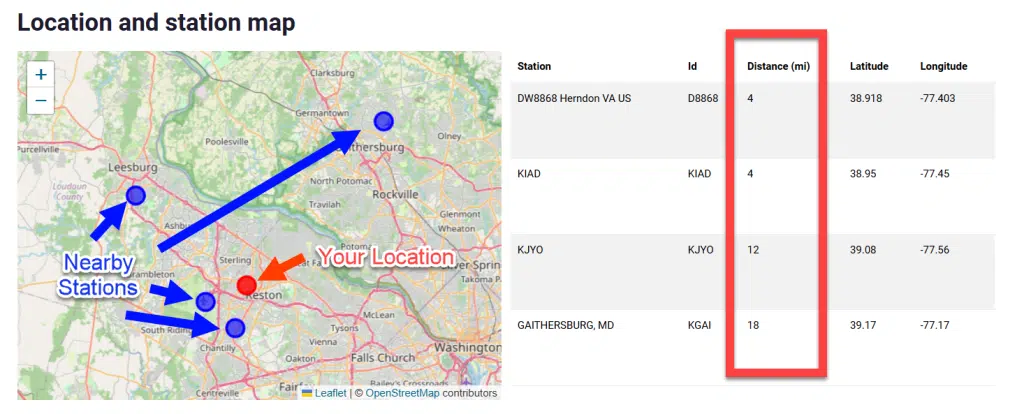
The results will show you a dashboard of the weather history for this location and a Location and station map of your location represented as a red point as well the nearest weather stations represented by blue points.
Next to the map you see a list of the stations. The list of weather stations will show the station name, ID (often the airport appended), distance from the location you entered and finally the latitude and longitude
How Visual Crossing uses nearby weather stations
Finding the nearest weather station is useful for understanding the observation network around a location, but Visual Crossing historical weather is not normally just a copy of the single closest station.
Visual Crossing can combine observations from multiple nearby stations to produce weather representative of the requested location. By default, the Weather Data Engine targets up to three station observations for each record, with closer and higher-quality stations generally receiving greater weight.
Depending on station availability, date, weather element, and location, additional stations or remote observation sources such as radar and satellite data may also be considered.
Therefore, the nearest station shown on the map is useful context, but it should not automatically be interpreted as the sole source of every returned weather value.
Additionally, Visual Crossing uses the multiple station approach to cleanse inaccurate or missing data. On rare occasions, data for a specific location may be missing or incorrect. By comparing data across stations, a more accurate report can be determined by eliminating empty values and values that outside of reasonable ranges.
Requesting data for a particular weather station
You can request data for a particular weather station by setting the requested location to be stn:<stationid> where <stationid> is replaced with weather station id found in the map above. For example, stn:KIAD. Requesting stn:KIAD asks specifically for data associated with that station. Querying an address or latitude/longitude allows Visual Crossing to produce weather representative of that geographic location using the available observation sources
Questions or need help?
For immediate help, try our AI Support Assistant, which can answer questions about Visual Crossing Weather data, APIs, documentation, and common technical issues. You can also post questions on our actively monitored support forum or contact our Support Team directly.