

The weather data returned by the Visual Crossing Weather API and Data Query Builder includes both the amount of precipitation and also the type of precipitation that occurred or is forecast to occur. In this article, we discuss the exact difference between the possible precipitation types that you may encounter.
Where to find the precipitation type field
By default, queries that retrieve weather data from the Visual Crossing Weather Data products will include the precipitation type, in addition to the amount of precipitation. The amount of precipitation is always included as the liquid equivalent of the precipitation, even if the precipitation was frozen. This provides both accurate reporting and accurate comparisons of the total amount of precipitation that falls over time no matter what form of precipitation falls.
To retrieve precipitation data, you can use the Weather Data Query Builder to retrieve precipitation data in the browser or download the data in convenient formats such as CSV or Excel format. You can also use the weather API to retrieve data in JSON or CSV format for automated tasks such as database loading, app or website integration.
What do the precipitation types mean?
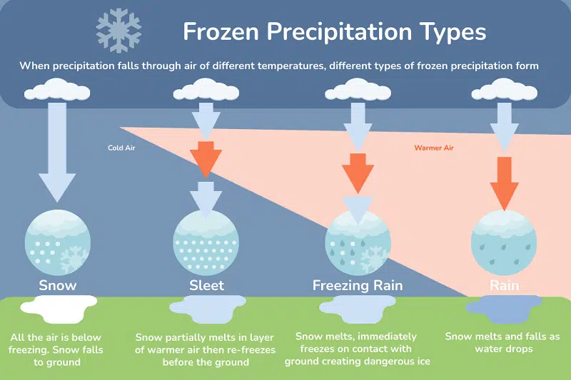
There are a number of precipitation types that are returned as part of of weather data.
Rain
Rain is simply liquid precipitation that falls from the sky and remains a liquid after contact with the ground. In this case, the air near the ground is above the freezing point of water 0C (32F) and the ground is also above freezing (if it’s not, freezing rain may occur). Note that in most cases, the clouds above the ground are cold and the rain begins in a frozen snowflake form in the clouds aloft.
Freezing Rain and Ice
Freezing rain is also in liquid form as it falls towards the ground however on contact with the ground, it immediately freezes. This creates various dangerous situations where ice coats trees, roads and powerlines, sometimes with thick layers of ice.
To create freezing rain typically requires particular atmospheric conditions where the precipitation falls through layers of air that are either above of below freezing. In most cases, the air high aloft will be below zero. As the precipitation falls, the precipitation encounters warmer air above freezing and the water melts to liquid form. However, close to the ground another layer of colder air is encountered. This cools the liquid, often to a ‘supercooled’ level where the precipitation remains liquid even though its temperature drops below normal freezing temperatures. Once the supercooled liquid impacts the ground, it immediately turns to ice.
Sleet
The process of creating sleet is similar. The atmosphere includes layers of warmer air that are above and below freezing. However, unlike freezing rain, the warmer layer is not thick and the frozen snowflakes only partially melt. When these partially frozen drops encounter the colder air near the surface, they refreeze.
This is significantly less dangerous than freezing rain as the sleet impacting the ground is unable to create a coating of ice. In many cases, the drops of sleet bounce on impact with the ground.
Snow
In the case of snow, the falling precipitation never encounters a layer of air with temperatures above freezing then snow is formed and falls all the way to the surface.
New snow will typically cause an increase in the snowdepth field providing the snow does not melt or get washed away by subsequent rain. Snow depths are not reset by a single day now fall snow or snow melting. Instead they are measured continually, rising when new snow falls and reducing when the snow melts or the snow compacts with time.
Where to find weather data?
You can find precipitation weather data for free using the Visual Crossing Web Site Tools. If you need more data, or want to access the data via a Weather API to import data into your app, Excel, database or any other data analysis tool, check out the Weather Data Query Builder and Weather API.