The Weather Data Downloads and Weather API retrieves historical weather data from ground based weather stations, in addition to remote dat
The Weather Data Downloads and Weather API retrieves historical weather data from ground based weather stations, in addition to remote data such as satellite and radar. Where possible, we bias the results towards the data provided by surface observations stations as these results produce the highest quality data, as well as most consistent.
a such as satellite and radar. Where possible, we bias the results towards the data provided by surface observations stations as these results produce the highest quality data, as well as most consistent.
Rather than simply choosing the data from the nearest weather station, the data definitions provide flexibility what stations are compared and then merged together to provide the most accurate picture of the local weather observations possible.
Why do we merge multiple weather stations?
In most weather data and weather API requests, the requested location is not immediately next to a weather station but nearby multiple stations.
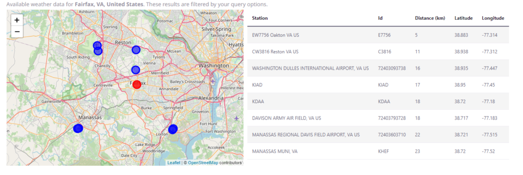
For example, consider the weather stations near to the city of Fairfax in Virginia, USA:

As the map shows, there are a number of stations nearby including both personal weather stations and official stations such as Dulles Airport in the north west.
Rather than choose a single weather station, the Visual Crossing Weather Data Engine merges the data from each station. This helps eliminate biases in one direction or another. For example, in this location the stations to the south east (the Davison Army Airfield) are located at lower elevation near the Potomac River where the temperatures are warmer. The stations towards the west such as Dulles and Manassas Airports, are located at higher elevations and will be slightly cooler. Fairfax is location in the center and therefore it provides a more accurate picture to combine the slightly warmer observations from the east with the cooler temperatures to the west.
The values from each station are weighted according their distance from the location and their overall quality score. Stations that are closer, and those with higher quality scores will be weighted more heavily than those that are farther away or with lower scores. Most official stations from recent years will have excellent quality scores in which case their distance is the predominant factor. A station that is closer will be weighted significantly higher than those further away. Therefore, for locations where there is a single nearby station, the reported data will be predominantly from that single station.
Weather station filtering
We use a number of parameters to customize the weather station search and merge calculation.
Maximum number of stations (maxStations)
This settings governs the target number of station observations that are require for each row of result data. For example, if a request is made for hourly data then the Weather Data Engine will target to merge data from at least this many stations for every hour of data.
In some cases, where weather stations change or are unavailable temporarily, the engine requires additional stations to ensure all hours have at least three station observations for every record. When additional stations are required to complete an observation row, those stations are used for all hours in addition to the three stations.
By default, we set this to parameter to three. Three enables us to have enough data for a ‘buddy check’ quality process where we compare the values from each station to ensure that they are consistent with each other.
Maximum distance to station (maxDistance)
The maximum distance to station parameter defines how have far away from the requested location we include stations. If you want to only consider stations that are closer to your selected location, then you can reduce this value. If you are querying remote locations, then you can increase the value up to a maximum of 200km (about 125miles).
By default, we set this to 50 miles or approximately 80km (80,467m).
Maximum elevation difference (elevationDifference)
In mountainous locations, nearby weather stations can be located at significantly different elevations where the weather conditions can be significantly different. The elevation difference parameter allows filtering of stations that are either significantly higher or lower than the target location. Any weather station that has an elevation difference between the station and the query location greater than this value is excluded from the results. Note that this value is always given in meters regardless of your query units setting. Default is an unlimited elevation delta.
Questions or need help?
If you have a question or need help, please post on our actively monitored forum for the fastest replies. You can also contact us via our support site or drop us an email at support@visualcrossing.com.
