

After a storm system moved northeast from the Texas Panhandle, 12 weather-related injuries were reported by hospitals in Norman, Oklahoma.
Oklahoma ranks third among U.S. states regarding tornado frequency, with an average of roughly 67 twisters occurring each year. According to the National Oceanic and Atmospheric Administration (NOAA), in 2022, the state experienced 57 tornadoes, with many of them wreaking havoc on Pottawatomie and Seminole counties. So far in 2023, Oklahoma residents have already witnessed five tornadoes touching down in the state. Unfortunately, climate change is anticipated to contribute to an above-average tornado season in 2023.
Each year, from April through June, Oklahoma experiences tornado season. This is when warm, humid air from the Gulf of Mexico combines with chilly, dry air from Canada and warm, dry air from New Mexico to create favorable conditions for tornado generation. Residents of Oklahoma should always be on alert for tornadoes, but late spring and early summer are challenging times. Thus, it is suggested that locals should be especially ready during these months.
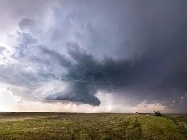
According to authorities, two tornadoes reportedly swept across Oklahoma on Sunday night, injuring at least 12 people. One tornado was recorded in the west-central part of the state, and it touched down near Norman, Oklahoma, about 20 miles south of Oklahoma City. A powerful storm outbreak with high winds and tornadoes traveled northeast from the Texas Panhandle. During a press conference on Monday, Norman Police Chief Kevin Foster said that none of the injuries were considered life-threatening.
Chief Foster claims that several houses, stores, and schools in Norman were severely damaged or destroyed by the storms. He also said that numerous routes were closed because of fallen power lines.
Local news station, News9, reported that the storms were so intense that one vehicle was overturned onto another. Additionally, footage captured by KOCO-TV showed several buildings, including a barn with horses still inside, with roofs torn off by the storm. The National Weather Service office in Norman, which had been closely monitoring the weather system, summed up the storm coverage on Sunday evening with the words, “It has been a day.”
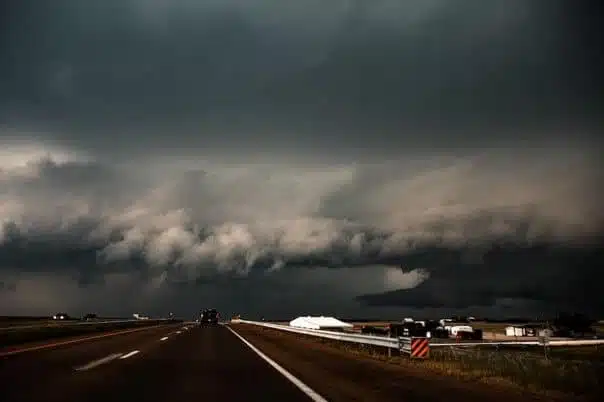
According to meteorologist Marc Chenard from the National Weather Service, a third tornado caused damage to a home and knocked down trees and power lines in Liberal, Kansas. As of Monday morning, PowerOutage.us reported that over 16,000 customers in Oklahoma were without power, while a small number of electrical outages were reported in Missouri and Texas. Wind gusts of up to 114 miles per hour were recorded in Hall County, Texas, with the Weather Service also noting widespread gusts ranging from 70 to 90 m.p.h. in southwest Oklahoma. Additionally, on Sunday evening, the Weather Service warned residents of McLean, a town located 75 miles east of Amarillo, Texas, to seek shelter from a potential tornado.
Forecasters at the Weather Service’s Storm Prediction Centre in Norman predicted that the storm would develop into a derecho, a line of thunderstorms that moves at high speed and covers more than 240 miles. As the second-highest danger level, the storm that affected a large section of Oklahoma was rated as “moderate” by the National Weather Service. Gusty winds were expected to continue until Monday afternoon, even though the severe weather advisories, watches, and warnings issued around the state had already ended.
The Storm Prediction Centre has warned that severe thunderstorms are possible in parts of Illinois and Ohio as the weather threat moves to the Midwest. Strong winds from the thunderstorms may cause damage in the Ohio Valley, and twisters might form throughout the state.
Chief Meteorologist Damon Lane presents the latest severe weather outlook for this spring. The most recent data indicates that the weather pattern we have experienced lately will persist throughout the season. Oklahoma is known for having some of its wettest months in April, May, and June. This spring will likely see these months continue to be among the wettest, with an increased likelihood of above-average rainfall for much of the region.
Western Oklahoma, which has been experiencing drought conditions, is expected to experience a substantial improvement in drought conditions this season as storms begin to form in the west and bring a significant chance of above-average rainfall. The risk of tornadoes is expected to remain high this spring, as the conditions are conducive to an above-average frequency of tornadoes.