

There are two types of Location sources that can be provided to the Weather Excel Add-in: Latitude/Longitude and Address. This article describes how to use both forms.
Latitude/Longitude Location Source
Latitude and longitude are used to locate points on the globe as a pair of coordinates represented by numbers. Latitude represents how far north/south the point is and longitude represents how far east/east the point is. The numbers are often expressed in degrees because the earth is approximately a sphere. We use 360 degrees of longitude for a full circle (east to west) and 180 degrees of latitude for the half circle of north-south. To make life more interesting, we don’t use 0-360 longitude and 0-180 degrees latitude though. The standard representation uses -180 to 180 degrees for longitude and -90 to 90 degrees for latitude.
Setting up Latitude and Longitude Data
To use latitude and longitude data, create two separate columns in the input dataset – one for latitude and one for longitude.
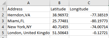
Note: It is recommended that you use the column names “Latitude” and “longitude” so that the Visual Crossing add-in can automatically detect these columns as location data. In practice you may use any column names that you want. However, you may need to select those as location columns manually within the Visual Crossing tool.
Latitude values must range from -90 (at the South Pole) to 90 (at the North Pole), and they must be a decimal number. See the blog post references above if you need help converting other formats of latitude and longitude.
Longitude values must range from -180 to 180. 0 is the prime meridian through London, United Kingdom. Positive values are East of London (that is, most of Europe, Asia, the Middle East and Oceania), negatives values are west of London (North, Central and South America).
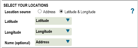
Below is a screenshot showing the completed Location Source configuration for the above data:
Note that if you have both address and latitude/longitude data, it is generally better to use the Longitude/Latitude as it will result in faster weather data look ups. In addition, the source of your data may have been able to provide more accurate latitude/longitude values (via GPS for example) than a geocoder can determine from an address alone.
Address Location Source
if your data include address information but no longitude/latitude information, the add-in can look up the longitude/latitude automatically through a process known as ‘Address geocoding’. This process uses an system to look up the matching latitude/longitude based on an address.
Setting up Address data
To configured address based location source:
1. Create a single column with a fully combined address value. The more specific and accurate address information provided, the more accurate a match can be determined. City names and other more general location identifiers are permissible, and a best match will be determined based on the information provided.
2. Select the address column as part of the data range selection.
3. Choose the address column for the location source. It is recommended that you name your address column ‘Address’ where possible. If you do so, Visual Crossing will be able to automatically chose it as a location identifier that requires geocoding. You may chose a different column name, however. Just make sure that you select it properly in the weather configuration panel.
4. Optionally choose a name column. This is the column in your data that most closely represents the “name” of the location. This name value will be copied into the output data for joining or analysis. Note that you can set this value to your address column itself if no other columns are ore appropriate.
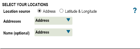
Below is an example of a properly configured address location source.
Other location sources
As mentioned above, the address geocoding process can also handle other location look-ups. If your data provides a city name, ZIP code, postal code etc., most of these can be processed providing that you give the country or state in addition. For example, although not recommended a city name of “New York City” alone may provide a unique and correct geocoding match. However, the city name “Herndon” will not. In this case you should use “Herndon, VA” or even “Herndon, VA, USA” to be fully precise. The less precise you are in your data, the more “guessing” the geocoder is forced to do thus increasing the chances of erroneous results.
Additional types of location look-ups are planed in the near future. If you have suggestions please let Visual Crossing support know which type look-ups you would be of interest to you.