

As winter starts in the Northern Hemisphere , schoolchildren are hoping for a “snow day” – a day where school is cancelled and everyone gets to build snowmen and launch a few well-aimed snowballs at their neighbors. However for children in the North-East of the United States, in cities including Richmond, Washington, DC, Baltimore, Philadelphia, there is a familiar gloomy prediction from the local TV stations – ‘the snow will be heaviest north and west of I-95’.

Interstate 95 (I-95) is the major north-south interstate (or motorway), that connects the major cities of the East Coast of the US. Why would a road be the delineation between a fun break from school and disappointed children staring at a cold rain from the classroom? Is it a coincidence or is the position of a the major cities that I-95 connects also a reason for the differences in snow fall?
In this article, for reasons that might explain why the position of the cities might explain the snowfall differences.
Why are the major cities of the Eastern US located where they are?

If we examine a map of the US, we can immediately see that major Atlantic coast cities are located on rivers. This is understandable. When the cities were settled and developed in the 16-18th Century, the most efficient transport was by boat. Efficient transport by boat requires water that is not obstructed by waterfalls or rapids. This led growing cities developing at the point furthest in land that was still navigable to the ocean without obstruction.
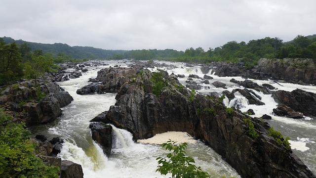
Along the east coast there is a continuous 900 mile long geological feature known as the ‘fall line’ or ‘fall zone’ – the Atlantic Seaboard Fall Line. This fall line is the point where the major east coast rivers pass from hard rock to the the sandy coastal plains and is the head of navigation of the rivers (without assistance from locks etc).
In many cases, this transition is marked by waterfalls and rapids such as as Greats Falls near Washington, DC, the rapids in Richmond, Virginia that and Schuylkill Falls near Philadelphia, Pennsylvania.
In addition to providing a barrier to easy navigation, these falls provided valuable energy for factories using water power.
We therefore can now understand why the east coast cities grew where they did. Road builders then joined the cities together for transportation. Interstate 95, running from Miami to Canada, being the main North-South artery.
Can the fall line also be a hint on why snowfall is higher west of I-95? Let’s look at a typical snowfall event on the East Coast.
Typical snow events on the US East Coast
Snow needs two main ingredients – moist air full of water and cold air that is cold enough to form snow. The East Coast experiences different types of storm – some may be cold enough but not hold enough moisture to create a heavy snowfall event. Some may be full of moisture but not be cold enough to snow, producing rain instead.
There are a number of types of storms that can bring to the East Coast of the US – Nor’easters, Alberta Clippers, Lake Effect Snow and Squall Lines. The last two are less influential for this discussion – Lake Effect Snow is only typically found in areas nearer the Great Lakes and Squall lines are less common.
Nor’easters
Nor’easters are the big snow makers for the east coast. They are formed when a central low pressure moves north along the US East Coast, deepening as moves. There have been found to be two main type of Nor’easter – one that forms in the warm waters Gulf of Mexico or Atlantic Ocean and one that form in the midwest (or central) United States (Miller “Type A” vs Miller “Type B” storms).
Those storms coming from the warm, moist waters of the Atlantic and Gulf will hold a great deal of moisture. If they are able to meet cold air from the North, these type of storms can produce very high snowfall totals. In February 2010 a Nor’easter tracked north up the Eastern US from Baja California Sur, bringing snow totals of 20-35″ (50-90cm) and earning the nickname “Snowmageddon”.
Alberta Clippers
Alberta Clippers are fast moving weather systems that originate in Canada. They often are characterized by strong winds and large temperature drops – sometimes as great as 30F (16C). As they are fast moving and don’t have access to as much moisture as a air masses from the south, Alberta Clippers generally don’t produce a large snowfall amount.
Are the snow-maker weather systems influenced by the fall line?
As the weather systems move northwards, they often battle the warmer air found near the Atlantic Ocean. It is in these transition areas where a storm will change between a snow, mixed precipitation or rain-only event. In the case of the Nor’easter, the warmer, moist air is found a the coast. The colder air in the West, often driven by a polar high pressure system over Canada.
This cold to warm transition zone is further increased by the presence of the Appalachian Mountains, which are found to the west of the I-95 corridor. This elevation increase starts at the fall line, the geological boundary between the low-levl coastal plains and the foothills of the Piedmont. The fall line is the historical edge of this range mountains and is the point at which the elevation of the land starts increasing. In the short distance between Washington National Airport and Washington Dulles Airport, both near Washington DC, the elevation increases over 300 feet (90 meters).
During a storm where the cold, Canadian high pressure system interacts with the warmer, moist low off Atlantic Ocean, the few degrees difference in temperature found where this elevation change occurs can make all the difference.
It is therefore natural that the Interstate 95 is the boundary between a system producing all snow or mixed precipitation or just rain only. I-95 joins the major cities of the North East United States and those cities were placed because of the same elevation transition that can also cause a transition in the in the type of precipitation we see in winter storms.
The Northeast area of the United States has a population of over 50 Million people (in 2010), most of whom live near the I-95 corridor and therefore live near the fall line. This means they also live near the exact location of the transition zone from snow to rain in a typical storm. Given that the location of the line between rain and snow in a storm dictates the amount of snow, this means a huge population of the US are extremely sensitive to the path of the storm, where warmer or colder air ‘wins’ and so where the predicted snow-rain line occurs. A difference of just 50 miles will mean millions of people either think the forecast is ‘wrong’ or ‘right’.
More importantly, 10,000s of school children will be disappointed or elated that the snow day they had hoped for either arrived or failed to materialize.